Revolutionizing The Way We See The Forest
There are many scattered panoramic outlooks across the Upper Midwest to view the beautiful landscapes of the region. Have you ever wondered what an image of your property may look like from a bird’s eye view, similar to these scenic overlooks? Over the past twenty years, readily available satellite imagery has greatly improved to now being able to view nearly all of the United States in 1-meter resolution. How would you like to see a map of your property at a resolution of just over 1-inch? It is said that a photo is worth a thousand words, well how many words do you think a short two- to three-minute video of your property would translate to? These questions, along with so many others (including those related to more traditional forestry), are now possible to answer with a prosumer-grade drone.
Drone services that we offer
Aerial Drone Photography
Green Timber currently flies a DJI Mavic 2 Pro drone. For this drone, DJI teamed with Hasselblad cameras to equip this drone with what may be the best camera in this drone’s class. This camera, when combined with amazingly steady flight technology of a DJI drone, makes capturing stunning aerial photography a breeze. From sweeping landscape images, to close in shots of an object of interest, the possibilities are only a click of the shutter button away.
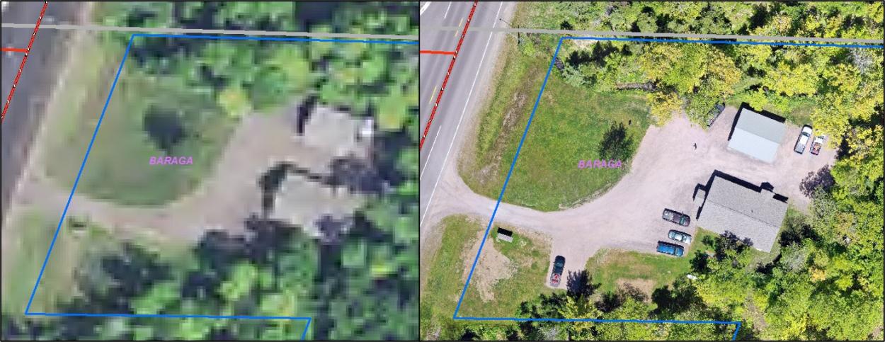
Real-Time GIS Aerial Map
Through the utilization of Drone Deploy software, Green Timber is able to use their drone to capture imagery, very similar to how satellite imagery is collected, to produce maps which are real-time to the day the imagery is collected. When high resolution imagery of an area is desired, Green Timber builds a flight plan in Drone Deploy to capture images in succession to blanket the area. In the field, the drone is set on the flight plan, in which it automatically flies a route, capturing images at pre-determined locations.
Back in the office, these images are uploaded to Drone Deploy, where they are “mosaicked” together to form a single map image. This map image is also georeferenced, meaning it can be brought into a GIS and readily viewed with other GIS layers and data. These finalized map images have a resolution of only an inch or two and are taken at a time of year that you specify as a client. Contrast that to satellite imagery with only 1-meter resolution, collected at a non-standardized time, every couple of years. As you can imagine, maps produced from drone imagery are revolutionary.
Aerial Drone Video
Maybe it’s stating the obvious, but one of the best things about drones is that they are not stationary, they are moving objects. Not only that, but they have a camera attached capable of viewing and capturing the drone’s view point as the drone moves! Green Timber uses this technology to even better highlight client’s properties. Instead of trying to describe how different images relate together, imagine capturing it all in a seamless video. Through the use of the drone, it’s camera, and video editing software, professional-quality videos are produced which display a property’s features in an all-in-one product.